Taking The (Literal) High Road

The Berkshires’ Yokun Ridge, known for its scenic vistas and distinctive ecology, is home to the first leg of the High Road, a venture of the Berkshire Natural Resources Council to create a web of interconnected hiking trails connecting towns to towns and towns to trails. The eight-mile footpath along Yokun Ridge links Pittsfield and Lenox along a clear and consistent hiking route.
The trail stretches from Bousquet Mountain in Pittsfield south to Kripalu Center for Yoga and Health in Lenox. If you’re up for tackling the whole eight miles in one fell swoop, plan to leave a vehicle at one trail terminus to transport yourself home (“car spot”) or arrange to be picked up at the end. While the trail can be hiked in either direction, this description depicts travel from north to south.
The High Road commences on a ski slope where hikers will follow blue blazes up .6 miles of steep trails to the kiosk marking the woodland start of the trail. From there, the Mahanna Cobble single-track trail takes one mile of switchback turns and stone steps before reaching spectacular views of Kennedy Park at the summit (plus a stone bench for resting and ample space for picnicking).
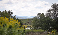
The Yokun Ridge Trail, traversing portions of Mass Audubon’s Pleasant Valley Wildlife Sanctuary, boasts moderate elevation changes and expansive views at Yokun Seat—whose moniker pays homage to Jehoiakim Yokun, a Native American of the Mohican tribe—and Lenox Mountain. Wide woodland trails and moderate elevation changes prevail throughout the watershed parcel owned by the Town of Lenox.
Yukon Ridge South is a wide woodland path with moderate elevation change via Old Baldhead Road, which passes Monk’s Pond. A detour from the High Road, the Burbank Trail offers a connection to Olivia’s Overlook—a popular scenic vista offering views of the Stockbridge Bowl—from which point another six miles of trails unfurl, easily navigable via the BNRC Berkshire Trails app and printable maps in both English and Spanish.
From there, it’s an easy woodland romp to the southern trail terminus, with the option of wandering through the Kripalu campus or heading into downtown Lenox, past the main entrance to Tanglewood via sidewalks lining West Street.
Since its founding in 1967, BNRC’s mission has remained “to protect and preserve the natural beauty and ecological integrity of the Berkshires for public benefit and enjoyment.” What began with nonprofit land conservation and environmental advocacy has evolved in recent years to include making these trails, and by extension this land—the ancestral homelands of the Mohican people who were forcibly displaced to Wisconsin by European colonization— accessible to all.
Unable to tackle the whole trail? Trailhead parking, for in-out hiking along the High Road, is available at Bousquet Mountain, Pleasant Valley Wildlife Sanctuary, Kennedy Park, Kripalu, and in the Lenox Village.
Related Articles
Hand-Picked Hikes: Favorite Trails From Those Who Know
These four hikes will whet your appetite for exploring the many trails in our region.
Please Support Rural Intelligence
We want to continue delivering the entertaining, informative and upbeat stories in the inimitable Rural Intelligence style, despite a pandemic. But we need your support to keep us going. Please consider making a donation; even a small amount helps secure our future. Support us now.
(If you prefer, mail a check to: 45 Pine Grove Ave., Suite 303, Kingston, NY 12401.)
Support Now